
When you head out to hit the trail or campsite, BackCountry Navigator Pro is just the tool you’ll need to find your way and stay on track. From Amazon:
Explore your world beyond the limits of roads and cell coverage.
Plan and navigate your next outdoor adventure using Backcountry Navigator Pro and enjoy the benefits of reliable mobile mapping software. Preload different types of maps for your destination from a variety of online, public-domain map sources. Just because your mobile network is out of its comfort zone doesn’t mean you have to be. Explore worry free.
Wherever you’re going, Backcountry Navigator Pro offers map choices for the locations that interest you. View and download topographic maps, color aerial maps, open street maps, and more for anywhere in the U.S. and Canada.
To find a map for any location using Backcountry Navigator Pro, tap your phone’s menu button and then tap the Maps option. View the available map options for each location category: Worldwide, US and Canada, Southern Europe, Western Europe, Central Europe, Oceania, and Microsoft Research Maps.
 Downloading and Viewing Maps Offline
While traveling within your mobile network or with Wi-Fi access, downloading a map isn’t necessary. Maps are displayed on your device from the internet as long as you have the Preview Enabled box checked. But this app isn’t called Backcountry Navigator for nothing. There’s a big and beautiful world out there and your cell coverage can’t go everywhere you can.
Backcountry Navigator Pro allows you to download free maps and save them on your SD card, making them accessible even when your mobile signal isn’t. This is ideal for backcountry activities or for travel in foreign countries where you’ll disable your data or lack cell coverage.
Download only the part of the map you want. To download map tiles for offline use, toggle the sculpt button and touch and drag a box to define one or more rectangles on the screen. Choose the map layer you prefer and the max zoom, then click download. You’re ready to explore.
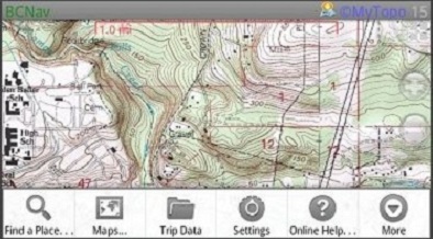
Backcountry Navigator Pro provides a user-interface that makes it simple to find a location, mark waypoints, store data, record tracks, and compute trip pace. Use the small plus tag to add a waypoint to your map. Pinch to zoom and finger swipe for easy map navigation. Tap the small box in the upper right-hand corner and choose to view the compass, waypoint list, or trip stats.
Set your location and enable a track recording using the target icon in the upper left-hand corner. Trip Tracks uses GPS to record your total distance, total time, elevation gained, and elevation lost. Enter any additional notes in the description field.
• View topographic maps showing terrain and contours
• Access a Variety of map sources for different kinds of free maps worldwide
• Download maps for offline use and store on SD card
• Search locations, mark waypoints, record tracks, and compute trip pace
• Check compass, waypoint lists, and trip stats
• Save, export, and import trip notes for future reference
• Alter Compass and Bearing, Coordinate, Display, and Storage Options
And if you’re thinking all of this sounds great, but what if your Fire’s battery runs out, no worries! All you need is a solar charger to keep your Fire and other devices juiced up and ready to go.
BackCountry Navigator Pro has an average customer rating of 4.5/5 stars across 20 reviews, and is currently priced at $9.99. This app is easy to use, yet powerful enough even for professional Search and Rescue teams. Reviewer Theodore W. Vogel says:
I’m very involved in K9 wilderness Search & Rescue and having such an excellent topo and aerial mapping application…is awesome! Backcountry Navigator incorporates several different map types and offers high quality topo and aerial maps, using both lat/lon and UTM grid references which is a very important feature for me. The great maps, in addition to GPS tracking and waypointing, make this a very valuable tool for my SAR toolbag.
Get BackCountry Navigator Pro, and never lose your way in the wild again!